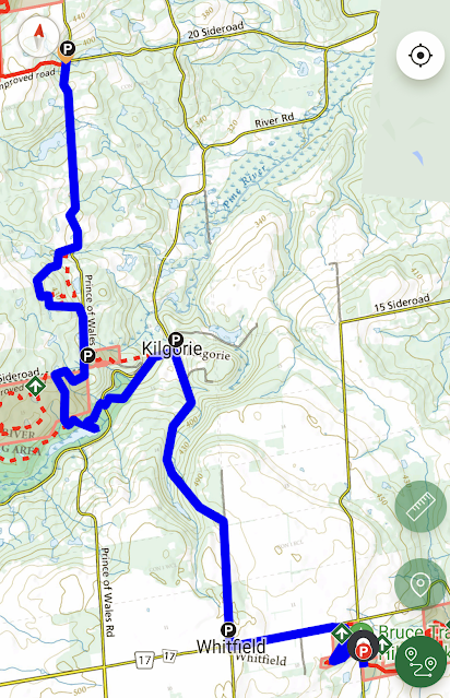
Dufferin Hi-land Section - Rock Hill Corner (28.3 km) to Prince of Wales Road (40.7 km) - May 9, 2024.
Dufferin Hi-land Section - Rock Hill Corner (28.3 km) to Prince of Wales Road (40.7 km) - May 9, 2024.
We idle for a few minutes to allow the other smaller, and very likely quicker, group to set off first...afterwards, it's just a short jaunt up the road to the entrance of Rock Hill Corner...
This 25 acre B.T.C Protected Natural Area is a gem of a place...from the road, you would never imagine how beautiful it is until you enter its realm...the numerous crevices and moss covered rock formations are highlighted by the dappled morning sunlight streaming through the fresh green foliage...Steve K crosses a cool "rock bridge"...
It takes about 30 minutes to wind our way through the area before we emerge onto 10 Side Road...
The other group of hikers is just a blip on the pavement ahead, we will never catch them now (not that we had any intention of doing so)..."in their footsteps" however, we walk westward towards Whitfield (or what's left of it, which is basically a church)...the sign says "God is Great", but even Jesus couldn't save this once bustling 1800's settlement formerly known as Beechnut Corners...
Well, haven't we been blessed with another stellar spring morning, and our right turn onto Centre Road leads us onto a lightly traveled dirt and rock route north that is bordered by the emerging greenery of the season...
As usual, when we come to a "fork in the road", we take it!..staying left actually, on Centre Road...(does that make us "left of centre"?)...we begin the long descent into the Pine River Valley...
A left turn onto River Road reveals another large hiking contingent, with several familiar faces among them, heading in the opposite direction (lucky them, they get to go up that crazy hill)...we stop and chat for a moment, but both groups soon head their separate ways...
The Pine River is in full flowing mode this morning and we pass by the long abandoned Dufferin Light and Power Company's generating building, sitting here watching unused energy go by since it shut down in 1927...
There's a quick crossing of River Road again that takes us into the Pine River Provincial Fishing Area...
The Bell Lookout Side Trail beckons and its 100 meter climb is worth the effort to catch the view and take our refreshment break...unfortunately the very pesky gnats are also fans of this area and made for a lot of swatting and annoyance so we didn't stay long...
The trail eventually emerges back onto the continuation of Prince of Wales Road at the corner of 15th Side Road...the area we have passed through, the Pine River Nature Reserve, is another recently established (2021) BTC Protected Natural Area of 192 acres which, as the sign suggests, was made possible by the generosity of a wealthy Toronto couple, Innes (d. 2005) and Felicia (d. 2022) van Nostrand...
...and, as a bonus, one more look out over the verdant valley...
The last stretch of road walking is a bit of a grind ("for sure the cars are just over this next hill, or around the next corner" type thinking), but eventually we make it back and it's the end of another great day on the Bruce...it's been good training for our upcoming trips to the Peninsula in a couple of weeks...hopefully we are blessed with the great weather like we have enjoyed on this day!..thanks for joining us and see you soon!


Comments
Post a Comment